THIS POWDER ALERT IS FOR BOTH TUESDAY & WEDNESDAY, THE 27TH & 28TH
Big Storm Continues Through Tuesday Night Ski
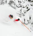
A cold front moves through the Pacific Northwest early Tuesday, dropping the sticking snow elevation from around 4,000' down to 2,500'. That means the quality of the snow will improve during the daytime as the moisture content lowers and temperatures drop.
Behind this system a strong west wind will really pile up the moisture up against the mountains. When that happens we get HUGE snow totals in the Cascades. Great for the slopes and deep powder is definitely ahead through the day and into Wednesday too.
STORM TOTAL SNOW ENDING LATE TUESDAY NIGHT
Upper Bowl: 25-28"
Temps: 25-30 degrees Tuesday, closer to 25 Wednesday at the base area

Long Range: Dry Wednesday, then a very weak system drags through the area Thursday night and Friday morning. Probably just a few inches with this one. One more system drops over us Saturday night and New Year's Day. Again, this one probably won't be a huge snow producer, but it'll be cold. That means more powdery snow instead of the wet stuff. Next week looks even colder...our big snowpack isn't going anywhere! No sign of pineapple express type systems in the next 7+ days.
Follow the latest on Facebook: https://www.facebook.com/skibowl and Twitter here: https://twitter.com/skibowl