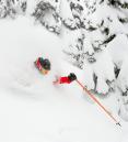
Good News! Thursday looks like the best day to enjoy fresh powder out of the next 7 days. Get up here if you can make it! If you can't, we have some warm "spring" sunshine coming up for part of the weekend and early next week.
A steady stream of cold showers should dump a total of 5-8" at Mt. Hood Skibowl by Thursday midday. That gives us a fresh base once the lifts start turning mid-afternoon.

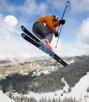
Temperatures warm a bit Friday with a rain/snow mix later in the day. Best skiing Friday will be before noon. Cooler again Saturday with a couple inches of fresh snow to start the weekend but partly cloudy skies otherwise.
LONG RANGE:
The big change is Sunday through the rest of next week. A strong ridge of high pressure, the first we've seen since fall, builds directly over the Pacific Northwest. Unusually warm air moves in Sunday for high temperatures pushing into the lower 50s...get out the sunscreen! More warm sunshine continues through at least next Wednesday.