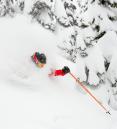
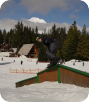
What a difference one year makes! Last year here at Mt. Hood Skibowl the slopes were mainly bare by mid-January. This year the slopes are loaded! A base of 55-75" from bottom to the top. Here at FOX12, while I work on a rainy valley forecast I always have a live camera feed of Upper Bowl just above me. I can confirm there aren't any rocks sticking out and folks are having fun while I'm working hard in here...
10pm Friday...
A nice cold storm dumped up to 8" Thursday night and Friday morning setting the stage for a great Friday. Now snow levels will rise tonight and go up/down over the weekend as several waves of precipitation move through. Here's the 3 day forecast, click for a better view:

It's important to point out the warmest conditions will be right away Saturday, then it cools in the afternoon. Late day and night skiing looks best Saturday. Monday will be the coolest day and likely dry.
STORM TOTAL SNOW TONIGHT THROUGH SUNDAY: 2-4" base and 10" on upper bowl
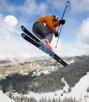
Here's to a great MLK weekend...far better than last year!
Long Range: The wet (in the valleys) and white (in the mountains) pattern continues through the foreseeable future. Snow levels will hover between 3,000 and 5,000' during this upcoming week.
Follow the latest on Facebook: https://www.facebook.com/skibowl and Twitter here: https://twitter.com/skibowl