THIS POWDER ALERT IS FOR FRIDAY PM & SATURDAY
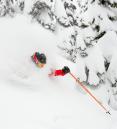
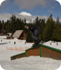
Best Powder in Several Weeks at Mt. Hood Skibowl!
It's been a warm 2-3 weeks up on the mountain, but we are getting a nice break Friday-Sunday; just in time for the weekend.
One cold front passed through the Cascades Thursday night and the following showers dumped 3-5" on the mountain. On Friday a cold front will drop snow levels further, ending up down around 2,500' by Saturday morning. When that happens the usual Cascade concrete turns drier and our wet snow goes dry (powder!). This 2nd cold front should drop lots more snow Friday afternoon through around daybreak Saturday. Both Friday afternoon/night and Saturday all day look like the best conditions we've seen in a few weeks. Maybe bluebird conditions Saturday afternoon too as skies start to clear too.

STORM TOTAL SNOW TONIGHT THROUGH SATURDAY AM
Upper Bowl: 15-18"
Long Range: Get it now while you can this weekend; the warmer weather pattern resumes Monday or Tuesday and continues through the end of the month.
Follow the latest on Facebook: https://www.facebook.com/skibowl and Twitter here: https://twitter.com/skibowl